


Santa Fe City and the Creation of FICH
Santa Fe City and its suburban area has a population of about half million, a significant proportion of whom occupy the floodplains of the Salado and the Paraná rivers. Historically, extreme high discharges of the Paraná River have periodically caused severe property damages to Santa Fe, most notably the big flood of 1982/83. After a major flood of the Paraná River in 1992, the city of Santa Fe with support from the State government decided to build several flood-control structures on the Paraná River, in the east part of the city, as well as along the Salado River on the Westside of Santa Fe. The main flood-control structure for Santa Fe against floods of the Salado River was the so-called Yrigoyen levee, running on the west side of the city for about 7Km and rising 5.2m above the floodplain level. Extremely high precipitation over the State of Santa Fe, north of Santa Fe city, saturated the lower basin of the Salado River during the first quarter of 2003. From April 21 to April 29, more than 400 mm of rain fell in some regions of the lower basin of the Salado River. The river overtopped its narrow and wandering channel and spread over its floodplain with unusual strength, destroying bridges and roads, and isolating some small towns in its run towards its outlet to the Paraná River near Santa Fe city. During the night of the 29th of April, the failure of a 150m reach of the unfinished Yrigoyen levee resulted in the rapid flooding of lowland neighborhoods, practically without warning. People in this area accustomed to coping with floods where water levels rise steadily but slowly faced a sudden increase of about 3 m of water in few minutes in some places. In the chaos of the first 24 to 48 hours of the flood, an estimated 120,000 people were displaced. Schools, clubs, government facilities, churches, and non-profit organizations of the city sheltered about 50,000 people, and approximately 70,000 people are believed to have sought shelter with friends and family all over the city. One third of the city was under water at some point.
The big flood of April 2003 was a tragic remainder that some lessons are still to be learned. While identifying and reducing flood risk is a multi-faceted effort, with the government bearing most of it, a necessary step was taken almost four decades ago when a local group of professionals created the Department of Applied Hydrology at the UNL in 1970. This academic boost in environmental sciences to the UNL was the local echo of the International Hydrological Decade, a 10-year program launched in 1965 by UNESCO that provided an important impetus to worldwide cooperation in Hydrology. Continuous activities in Hydrology and River Mechanics developed ever since by many faculties of the Department of Applied Hydrology gave later ground to the creation of the Water Science and Engineering Faculty (FICH) in 1985.
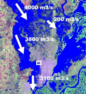

 From left to right: Spot image showing flow discharges estimated during the flood peak of April 2003;
Ironically, the site where Juan de Garay originally founded the city of Santa Fe has never flooded;
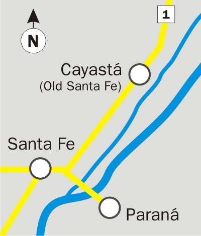
Location of the Old Santa Fe Town (Cayastá) with respect to the cities of Santa Fe and Paraná
From left to right: Spot image showing flow discharges estimated during the flood peak of April 2003;
Ironically, the site where Juan de Garay originally founded the city of Santa Fe has never flooded;
Location of the Old Santa Fe Town (Cayastá) with respect to the cities of Santa Fe and Paraná